Bere Regis Village Website

Walking around Bere Regis


** BBQs and campfire ban in Dorset **
Dorset Council is banning BBQs and fires at all of our country parks, and on Dorset Council land that is deemed to be a high fire risk.
We have been in touch with others in Dorset who are looking to do the same, and after a multiagency meeting in April 2021, we are leading on a coordinated campaign to address the wildfire risk from BBQs (especially disposable) and fires.

There are many interesting walks around the village and into the surrounding countryside using the plentiful footpaths and bridleways. 
To guide you along some of these ways, four local walks of varying lengths have been signed with green (Walk 1), blue (Walk 2), red (Walk 3) and orange (Wild Woodbury Walk) markers.
These walks can be picked up at any point along their routes and are signed for walking in both clockwise and anti-clockwise directions.
If you would prefer to follow written directions Walks 1, 2 and 3 are described on this webpage, starting at the main Village Car Park, off Turberville Road, Bere Regis (post code BH20 7LZ or three words processor.hides.denser).
The Wild Woodbury Walk starts at the Dorset Wildlife Trust’s Wild Woodbury site.
There is an on-site car park (post code BH20 7LL three words slave.clapper.shopping).
The map below shows all of the walks and some information about their length and the terrain.
More detailed maps for each of the four walks are also shown below.

To view and download the map pdf in your browser click the map. (Opens in a new browser window)
While following the walks, please respect our village environment and follow the Countryside Code.
In particular, take your litter home or dispose of it in a waste bin, always keep your dogs in sight and on a short lead near farm animals, bag dog poo and dispose of it in an appropriate bin or take it home with you, leave gates as you find them, and do not light fires or BBQs.
Walk 1. Bere Regis Village

Start and finish in Bere Regis Car Park, Turberville Road.
With the recycling centre behind you walk towards Turberville Court.
Turn right along a path with a wall on your right and walk down to a T-junction.
Here turn left and follow the path to the Church of St John the Baptist.
Enter the gate to the churchyard and bear right to the Church porch.
Do stop a while to explore this wonderful medieval building.
On leaving the Church turn left and follow the path keeping left at a Y-junction and then pass through the churchyard gate and follow the track with Stable Cottage on your right until you reach West Street.
Here turn right and at the Royal Oak pub turn left into North Street.
Pass the village hall on your left and continue along North Street until you reach a gate across the road.
Along the way notice the historic houses of which many are listed as being of architectural or historic interest.
Just before the gate across the road there is a track on your left.
Follow this track, which has a sharp left hand bend at the top of the hill, and continue along it until you reach a tarmac road. Continue along this road passing Boswell’s Close on your left side and then bear right at a junction and continue until you reach a T-junction.
Here, turn right and almost immediately left along Back Lane.
After passing the last house continue straight ahead along a path until reaching a dog waste bin by West Street.
Here turn left opposite the Old Mill B and B (an ideal place to stay a night and explore this historic village in more depth) and walk along West Street to The Drax Arms pub.
By all means take some refreshments at this community pub.
On leaving the pub, cross the road and walk along an alleyway which leads you back to the car park.

Walk 2. Bere Regis near countryside – May’s Wood and Bere Stream

Start and finish in Bere Regis Car Park, Turberville Road.
With the recycling centre on your right walk towards the bungalows then turn right and walk a short way through a parking area and then turn left along a short alleyway.
At the end of the alleyway, turn right and then almost immediately left down another alleyway to a road (Elder Road).
Cross the road and walk towards a No Through Road sign.
At the sign turn left and walk towards Souls’ Bridge.
Just before the bridge turn right and walk along a path with Bere Stream on your left.
Continue along a boardwalk with the stream still on your left.
At the end of the boardwalk bear left and continue along the path until you reach a bridge on your left.
Cross the bridge and turn immediately right following a path along the field edge until you reach a green lane with a wooden gate immediately facing you.
Turn left along the green lane path and continue straight ahead until reaching a T-junction.
Here, turn left and continue along the green lane ignoring the tracks to your left and right.
After a short uphill section you will reach another T-junction.
Here, turn left and walk downhill to meet a tarmac road.
Follow this road round to the right, with Souls’ Moor open space and then some watercress beds on your left until reaching a T-junction with the road to Wool.
Turn left along the road. Cross over the Bere Stream on the Southbrook Bridge and continue up the hill to The Royal Oak pub.
By all means take some refreshments at this pub (an ideal place to stay a night and explore this historic village in more depth).
On leaving the pub, turn left along West Street and after a short while turn left along Church Lane.
Enter the churchyard and pass the war memorial on your right.
Where the path divides turn right to the Church porch.
Do stop a while to explore this wonderful medieval building.
On leaving the Church turn right around its west end and exit the churchyard through a gate.
Follow the tarmac path straight ahead, taking the first right turn along an alleyway which leads you back to the car park.

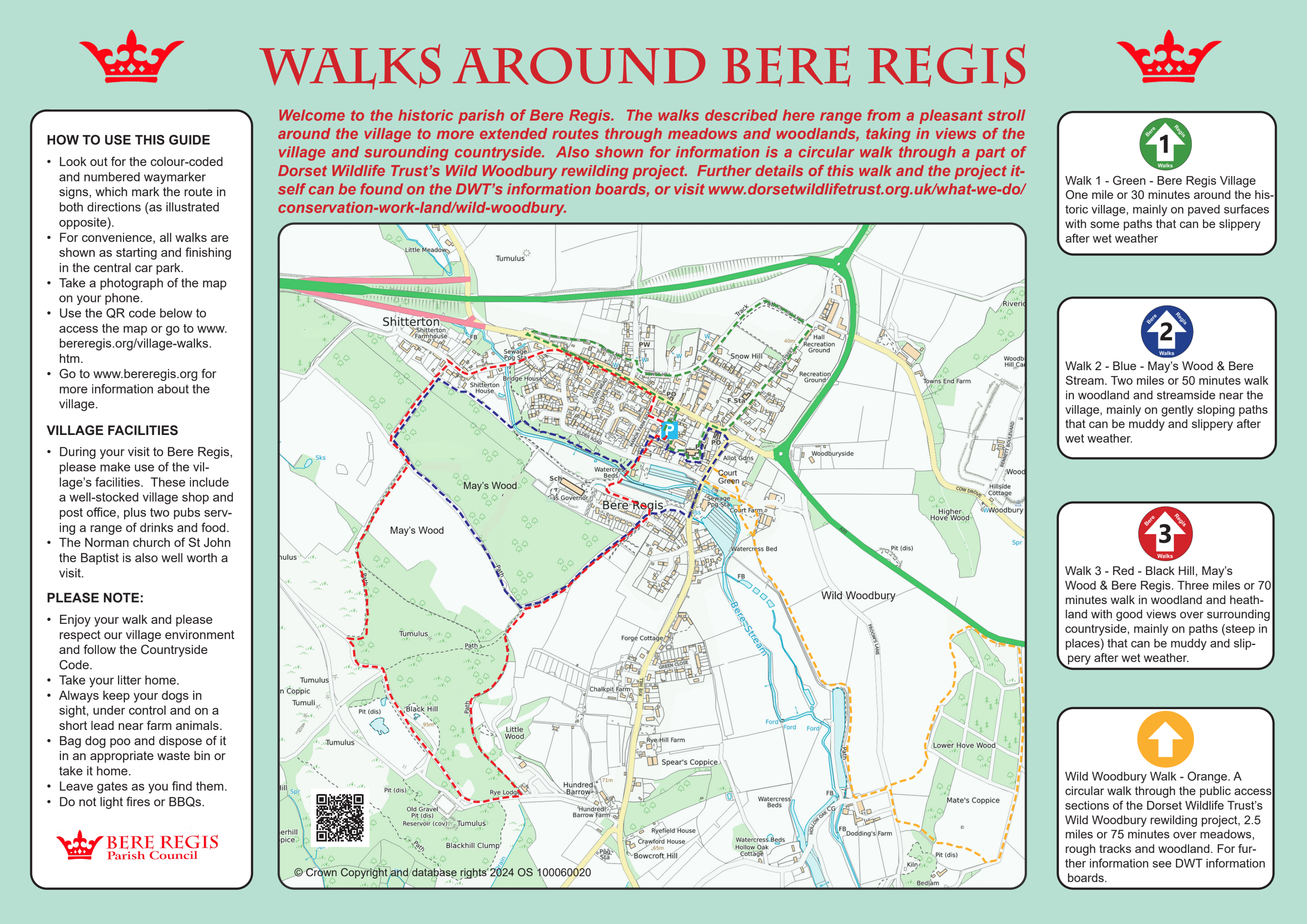
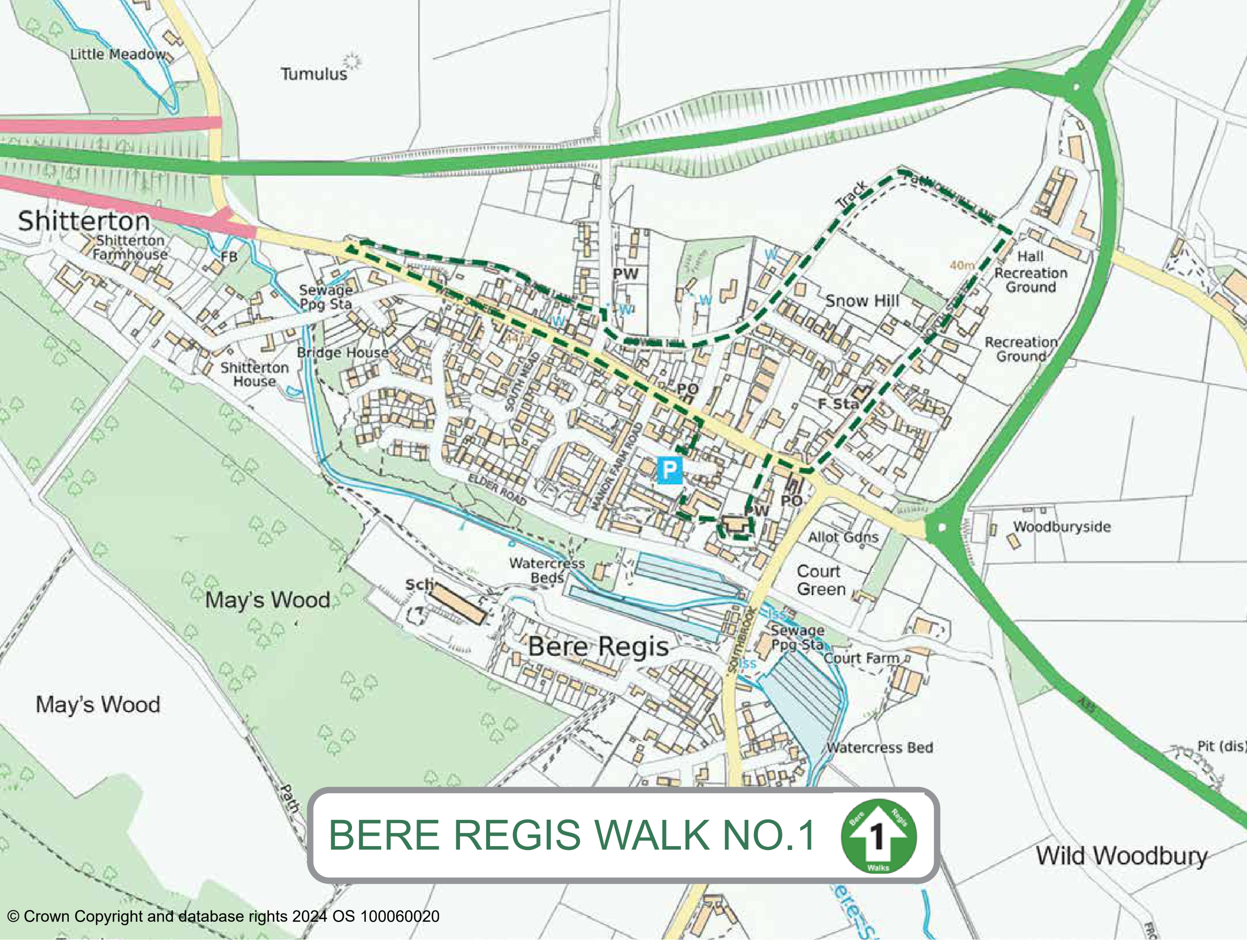
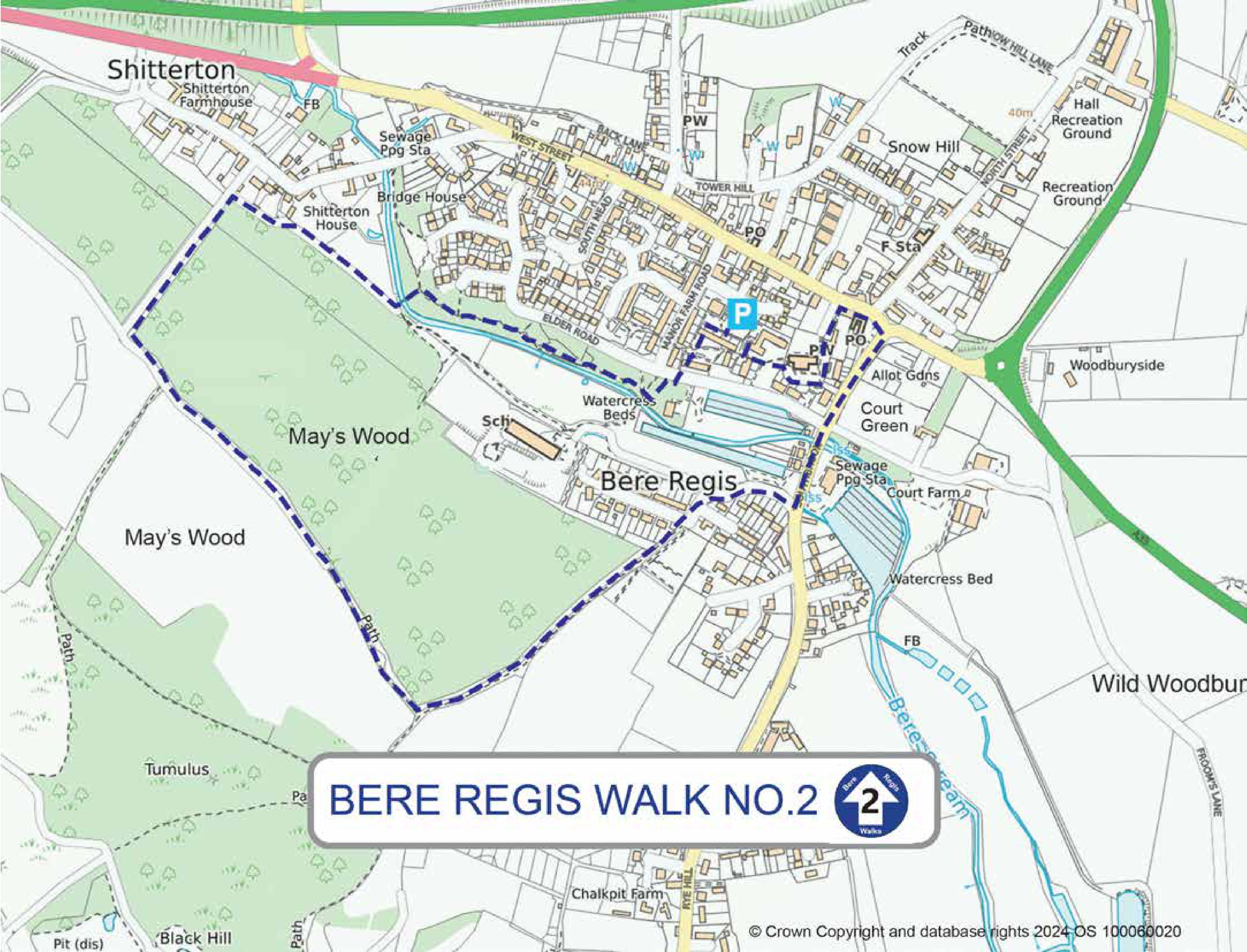
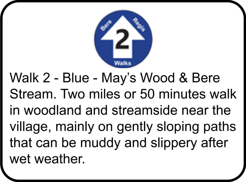
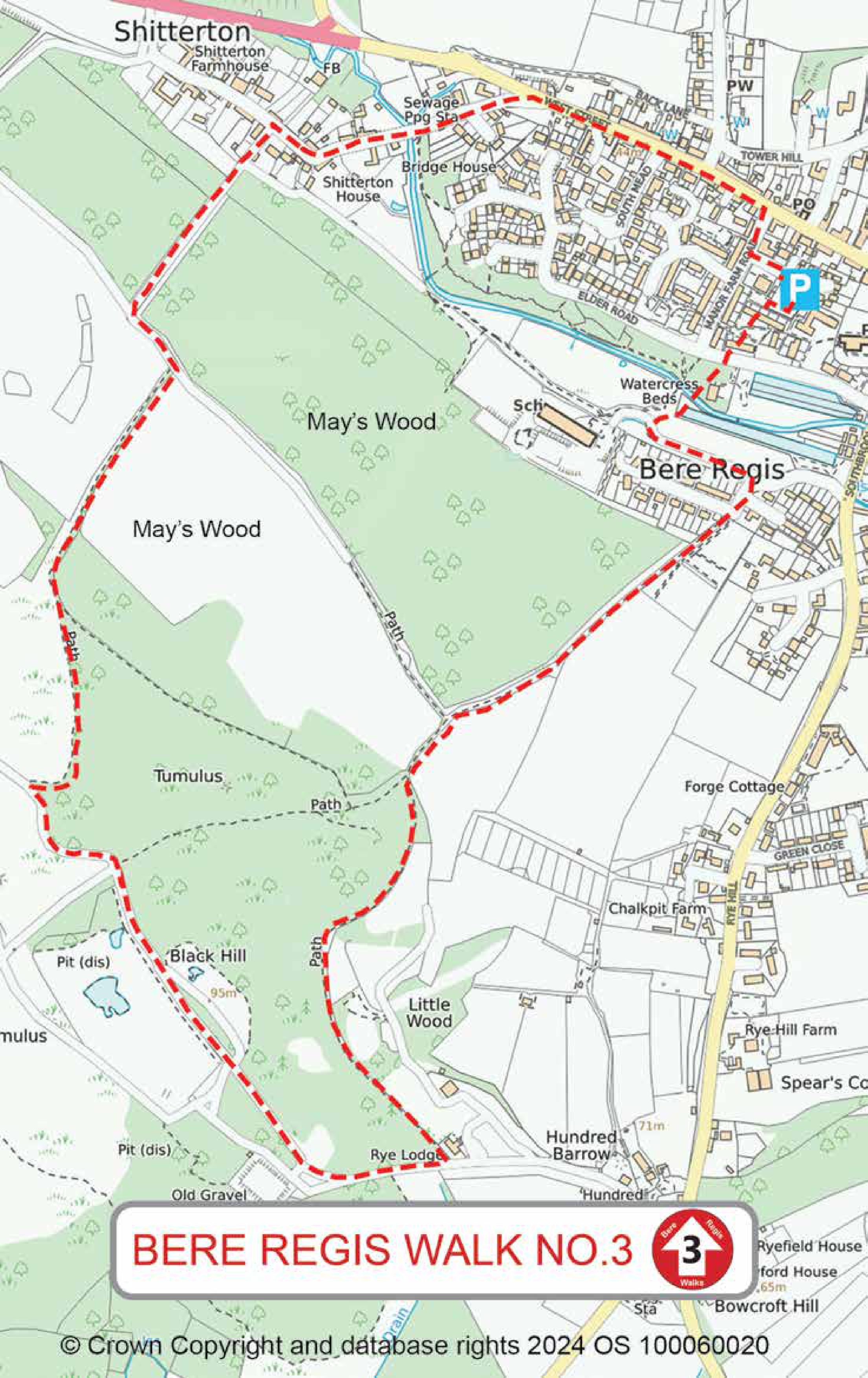
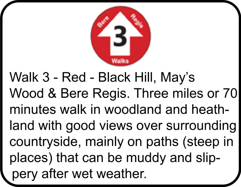
Walk 3. Bere Regis village, May’s Wood and Black Hill

Start and finish in Bere Regis Car Park, Turberville Road.
With the recycling centre on your right walk towards the bungalows then turn right and walk a short way through a parking area and then turn left along a short alleyway.
At the end of the alleyway, turn right and then almost immediately left down another alleyway to a road (Elder Road).
Cross the road and walk towards a No Through Road sign. At the sign turn left and walk towards Souls’ Bridge.
Walk over the bridge to cross Bere Stream.
On reaching the access road to Bere Regis Primary School, turn left along the road.
Immediately after passing a gate at the end of the school access road, turn right uphill with the cemetery gates on your left.
Follow the path uphill through the trees.
After about 450 yards you will pass two other paths joining from the right.
Continue straight ahead to a metal gate.
Pass through the gate and almost immediately bear left and follow the path alongside a fence for approximately half a mile, with woods to your right side and a disused camp site to your left side until you reach another gate.
Here, turn right and follow a track uphill.
Before reaching a large metal gate across the track turn right through a pedestrian gate and follow the path climbing onto Black Hill. When the path emerges from the trees ignore a track to the left and continue straight on along a track until reaching a crossing point of four tracks.
Continue ahead for about 200 yards, looking for a path coming in at a sharp angle from the right.
Take this path, which curves gently downhill to the left, until it reaches a gate.
Go through the gate and bear right along a sunken green lane through a tunnel of trees.
Ignore all tracks to the left and right and proceed to the end of the green lane to a T-junction with another track.
Turn left and shortly after right.
Follow the track, passing between some houses until reaching a road (Shitterton).
Turn right and walk along the length of Shitterton, with its many historic buildings, to its junction with another road, West Street. Turn right along West Street to the village centre for shops and pubs.
Return to the car park by turning right along Manor Farm Road and, just after the Doctors’ Surgery take the road to the left (Turberville Road).